Trail Walking Le Reposoir - Montée au Petit Bargy - Photo
 Chabard
Chabard

User

© OpenStreetMap contributors
Length
Length
10.4 km
Max alt
Max alt
2097 m
Uphill gradient
Uphill gradient
926 m
Km-Effort
Km-Effort  
23 km
Min alt
Min alt
1234 m
Downhill gradient
Downhill gradient
926 m
Boucle
Boucle
Yes
Creation date :
2024-08-11 05:20:29.0
Updated on :
2024-08-11 17:22:02.212

(0 Reviews)

Walking
Walking
4h01
Difficulty : Difficult

Scan this QR Code to open this trail in the SityTrail application

FREE GPS app for hiking

Logo SityTrail SityTrail

IGN / Geographical institutes

Download SityTrail from the App Store Download SityTrail from Google Play

Logo SityTrail SityTrail World

The world is yours!

Download SityTrail from the App Store Download SityTrail from Google Play Download SityTrail on Huawei AppGallery

About

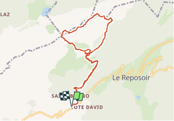
Trail Walking of 10.4 km to be discovered at Auvergne-Rhône-Alpes, Upper Savoy, Le Reposoir. This trail is proposed by Chabard.

Description

Superbe randonnée avec des paysages majestueux.
Départ du village de Saint-Bruno.
Passage à La Cha, ne pas manquer la grotte à la vierge et sa cloche.
Montée au Col d'Encrenaz.
Poursuivre jusqu'au sommet du Petit Bargy.
Traversée sur les lapiaz jusqu'à la Tête des Bécus
Retour à La Cha puis à Saint-Bruno.
Même s'il n'y a pas de difficultés techniques, cette randonnée est classée difficile pour trois raisons :
1. Les pente sont soutenues à la montée et à la descente.
2. Il faut mettre les mains pour monter au Col d'Encrenaz et pour certains passages dans les lapiaz.
3. Le balisage dans les lapiaz est sommaire et il faut faire attention à bien garder le chemin.
Il faut enfin noter qu'il n'est pas évident de trouver à se garer le chemin de Malatrait étant un chemin privé.

Elevation profile

Photos

Positioning

Country:
France
Region :
Auvergne-Rhône-Alpes
Department/Province :
Upper Savoy
Municipality :
Le Reposoir
Location:
Unknown
Start:(UTM)
307494 ; 5097515 (32T) N.

Trails nearby

Trail Walking Le Reposoir - Le Petit Bargy 2098 m, depuis Malatrait - Photo
Walking
tracegps

Walking

Medium
(1)
Le Reposoir, Auvergne-Rhône-Alpes, Upper Savoy, France
8.1 km | 18.8 km-effort
5h 0min
Yes
Trail Walking Mont-Saxonnex - Les Rochers de Leschaux, 1936m - Mont Saxonex - Photo
Walking
tracegps

Walking

Medium
(1)
Mont-Saxonnex, Auvergne-Rhône-Alpes, Upper Savoy, France
11.6 km | 20 km-effort
5h 0min
Yes
Trail Touring skiing Le Grand-Bornand - Col de Balafrasse et tout de la pointe Est du midi  - Photo
Touring skiing
GUIDE
nadd73

Touring skiing

Difficult
Le Grand-Bornand, Auvergne-Rhône-Alpes, Upper Savoy, France
14.6 km | 31 km-effort
6h 12min
Yes
Trail Walking Le Reposoir - au dessus de la grotte de motarquis - Photo
Walking
GUIDE
nadd73

Walking

Difficult
Le Reposoir, Auvergne-Rhône-Alpes, Upper Savoy, France
10.1 km | 24 km-effort
6h 0min
Yes
Trail Walking Le Reposoir - pointe blanche par l'arête Est - Photo
Walking
GUIDE
nadd73

Walking

Difficult
Le Reposoir, Auvergne-Rhône-Alpes, Upper Savoy, France
5.6 km | 17 km-effort
6h 0min
Yes
Trail Walking Le Grand-Bornand - Refuge Gramusset à partir de la Duche - Photo
Walking
GUIDE
HERRY

Walking

Le Grand-Bornand, Auvergne-Rhône-Alpes, Upper Savoy, France
12.7 km | 23 km-effort
4h 32min
Yes
Trail On foot Le Grand-Bornand - Move - Photo
On foot
Sebastienburette

On foot

Easy
(1)
Le Grand-Bornand, Auvergne-Rhône-Alpes, Upper Savoy, France
6.5 km | 11.5 km-effort
Unknown
Yes
Trail Walking Le Reposoir - lac peyre - Photo
Walking
Jeroen82

Walking

Medium
(2)
Le Reposoir, Auvergne-Rhône-Alpes, Upper Savoy, France
5.1 km | 10.9 km-effort
2h 26min
Yes
Trail Snowshoes Le Grand-Bornand - la duche, Col des Annes, Terres rouges  - Photo
Snowshoes
lizagreg

Snowshoes

Easy
(3)
Le Grand-Bornand, Auvergne-Rhône-Alpes, Upper Savoy, France
8.8 km | 13.4 km-effort
2h 20min
Yes


Close
My subscriptions